
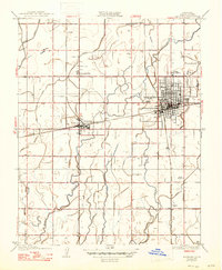
1926 Map of Hanford
USGS Topo · Published 1926About this map
Hanford serves as the bustling hub of this Central Valley landscape, its street grid and rail connections highlighting its role as the seat of Kings County. The map reveals an intricate network of water management essential to the region's agricultural foundation, dominated by features like the Mussel Slough and an expansive system of irrigation canals including Last Chance Ditch and Peoples Ditch. These waterways crisscross the terrain between smaller outlying settlements like Armona and Grangeville. Social infrastructure is well-documented through several rural schools such as Lucerne School and Rustic School, alongside the County Hospital. The intersection of the Southern Pacific and the Atchison Topeka and Santa Fe railroads illustrates the vital transportation corridors that shaped local commerce and settlement patterns in the mid-1920s.
Find a feature on this map
35 named features on this map. Tap any name to fly to it.
Don’t see what you’re looking for? This feature index may not catch every label — zoom into the map to look around manually.
Map Details
Editions of this 1926 Hanford Map
2 editions found
Other maps of this area

1924 · Riverdale
USGS Topo · 1:31,680

1926 · Burris Park
USGS Topo · 1:31,680

1927 · Laton
USGS Topo · 1:31,680

1927 · Remnoy
USGS Topo · 1:31,680

1927 · Riverdale
USGS Topo · 1:31,680

1927 · Lemoore
USGS Topo · 1:31,680

1928 · Waukena
USGS Topo · 1:31,680

1929 · Guernsey
USGS Topo · 1:31,680

1929 · Stratford
USGS Topo · 1:31,680
1940 · Stratford
USGS Topo · 1:62,500