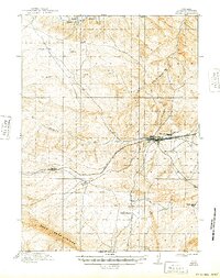
1914 Map of Hanna
USGS Topo · Published 1949About this map
Hanna serves as the central hub of this Wyoming landscape, positioned along the vital corridor of the Union Pacific R R. The surrounding terrain is defined by the high-elevation ranching and coal-mining environment typical of Carbon County during the early 20th century. Named outposts such as Brooks Ranch, Nelson's Ranch, and Kinney's Ranch are scattered across the high plains, illustrating the era's land use before later industrial shifts. Significant infrastructure projects are visible in the form of the Big Ditch, North Ditch, and Middle Ditch, which redirect water across the arid landscape toward the Medicine Bow River. To the south, the prominent Pass Creek Ridge and the Saddleback Hills provide a natural barrier, while the small settlements of Threetown, Dana, and Percy trace the path of the railroad as it winds through the high-desert topography.
Find a feature on this map
15 named features on this map. Tap any name to fly to it.
Don’t see what you’re looking for? This feature index may not catch every label — zoom into the map to look around manually.
Map Details
Editions of this 1914 Hanna Map
3 editions found
Other maps of this area

1893 · Fort Steele
USGS Topo · 1:125,000

1914 · Hanna
USGS Topo · 1:62,500

1914 · Walcott
USGS Topo · 1:62,500

1914 · Saddleback Hills
USGS Topo · 1:62,500

1921 · Saddleback Hills
USGS Topo · 1:62,500

1953 · Seminoe Dam SE
USGS Topo · 1:24,000

1953 · Schneider Ridge
USGS Topo · 1:24,000

1953 · T E Ranch
USGS Topo · 1:24,000

1954 · Rawlins
USGS Topo · 1:250,000

1955 · Coal Bank Basin
USGS Topo · 1:24,000