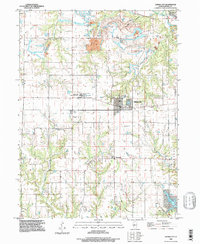
1996 Map of Hanna City
USGS Topo · Published 1997About this map
Hanna City serves as the central hub of this Peoria County landscape, appearing alongside the smaller communities of Eden and Smithville. The area's mid-century rural character remains evident through a network of family and community landmarks, including the Texas Ch, Cottonwood Ch, and Logan Sch. Water drainage patterns are well-defined by Kickapoo Creek in the northeast and Copperas Creek to the south, while Lake Camelot indicates residential development near Harkers Corner. Local institutions like the Hanna City State Work Center and infrastructure such as the Communication Tower and Sewage Disposal Ponds show the modernization of the territory. The map also captures remnants of local industry, such as a Pit near Coal Hollow, reflecting the region's geological transition into Limestone township.
Find a feature on this map
29 named features on this map. Tap any name to fly to it.
Don’t see what you’re looking for? This feature index may not catch every label — zoom into the map to look around manually.
Map Details
Editions of this 1996 Hanna City Map
This is the sole edition of this map. No revisions or reprints were ever made.
Other maps of this area

1893 · Dunlap
USGS Topo · 1:62,500

1898 · Dunlap
USGS Topo · 1:62,500

1905 · Peoria
USGS Topo · 1:62,500

1927 · Peoria
USGS Topo · 1:62,500

1930 · Glasford
USGS Topo · 1:62,500

1932 · Dunlap
USGS Topo · 1:62,500

1933 · Dunlap
USGS Topo · 1:62,500

1937 · Dunlap
USGS Topo · 1:62,500

1944 · Elmwood
USGS Topo · 1:62,500

1948 · Elmwood
USGS Topo · 1:62,500