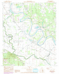
1989 Map of Hanna
USGS Topo · Published 1992About this map
The Red River dominates this landscape on the border of DeSoto and Natchitoches parishes, its shifting course creating a complex network of cutoffs and oxbow lakes. Settlements like Hanna and Lake End are positioned along the river’s historical corridor, where the land’s transformation by water is evident in features like the Hollingsworth Cutoff and Porters Island. To the south, Bayou Pierre meanders through the lowlands near Jims Island, illustrating the intricate drainage patterns of the Red River Valley. The map also reveals the area’s connectivity via the Jordan Ferry and the Jordon Ferry Bridge crossing Indian Bayou. This 1989 survey serves as a detailed record of local geography just before the modern era, capturing everything from the Red River Airport to the various spoil banks and gaging stations along the riverbank.
Find a feature on this map
37 named features on this map. Tap any name to fly to it.
Don’t see what you’re looking for? This feature index may not catch every label — zoom into the map to look around manually.
Map Details
Editions of this 1989 Hanna Map
2 editions found
Other maps of this area

1937 · Campti NW
USGS Topo · 1:31,680

1937 · Campti SW
USGS Topo · 1:31,680

1938 · Chemard Lake
USGS Topo · 1:31,680

1938 · Hollis Creek
USGS Topo · 1:31,680

1938 · Allen
USGS Topo · 1:31,680

1938 · Lake End
USGS Topo · 1:31,680

1944 · Campti
USGS Topo · 1:62,500

1947 · Ashland
USGS Topo · 1:62,500

1947 · Hanna
USGS Topo · 1:62,500

1948 · Coushatta
USGS Topo · 1:62,500