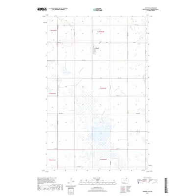
2017 Map of Hannah
USGS Topo · Published 2017About this map
Hannah sits at the heart of this Cavalier County landscape, characterized by the intricate drainage of Snowflake Creek and its various tributaries like W Snowflake Cr. The town's layout is centered on 1st Ave and 2nd Ave, surrounded by a vast grid of section roads including 108th St and Co Rd 13. For those researching local roots, the Hannah Cem is a primary landmark situated just north of the main settlement. The southern portion of the quadrangle is dominated by the expansive basin of Rush Lake, which serves as a significant hydrologic feature in an area defined by numerous small prairie wetlands. This 2017 survey reflects the enduring rural character of the North Dakota borderlands, where the landscape remains largely dedicated to agricultural use and natural water systems.
Find a feature on this map
26 named features on this map. Tap any name to fly to it.
Don’t see what you’re looking for? This feature index may not catch every label — zoom into the map to look around manually.
Map Details
Editions of this 2017 Hannah Map
This is the sole edition of this map. No revisions or reprints were ever made.
Other maps of this area

1953 · Devils Lake
USGS Topo · 1:250,000

1956 · Devils Lake
USGS Topo · 1:250,000

1970 · Sarles NE
USGS Topo · 1:24,000

1970 · Sarles SE
USGS Topo · 1:24,000

1970 · Hannah SW
USGS Topo · 1:24,000

1970 · Wales
USGS Topo · 1:24,000

1970 · Hannah
USGS Topo · 1:24,000

1970 · Hannah SE
USGS Topo · 1:24,000

1985 · Langdon
USGS Topo · 1:100,000
2011 · Hannah SW
USGS Topo · 1:24,000