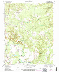
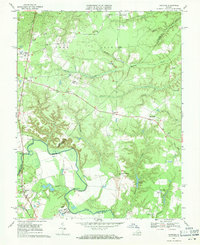
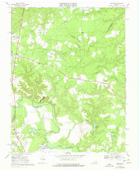
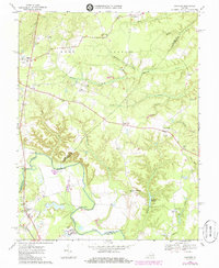
1969 Map of Hanover
USGS Topo · Published 1985About this map
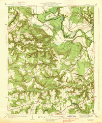
Pamunkey River winds through this rural landscape at the intersection of Hanover, Caroline, and King William counties. The terrain is characterized by the broad, wooded basins of Herring Creek, Dorrell Creek, and Mechumps Creek, where several small communities like Hanover and Mangohick serve as focal points for local history. Evidence of early industry and community life is found at Gravatts Millpond and Etna Mills, while spiritual life is documented through numerous country churches, including St Pauls Ch and Hebron Ch. The map also captures significant institutional sites such as the Hanover School For Boys and State Prison Camp No 2. Along the western edge, the Chesapeake And Ohio railroad line parallels the river, passing through the historic landing at Sturgeon Hole and crossing the water via Littlepage Bridge.
Find a feature on this map
48 named features on this map. Tap any name to fly to it.
Don’t see what you’re looking for? This feature index may not catch every label — zoom into the map to look around manually.
Map Details
Editions of this 1969 Hanover Map
4 editions found
Other maps of this area

1894 · Richmond
USGS Topo · 1:62,500

1895 · Richmond
USGS Topo · 1:62,500

1918 · Doswell
USGS Topo · 1:62,500

1918 · Aylett
USGS Topo · 1:62,500

1920 · King William
USGS Topo · 1:62,500

1933 · Aylett
USGS Topo · 1:62,500
1938 · Studley
USGS Topo · 1:31,680

1938 · Yellow Tavern
USGS Topo · 1:31,680

1943 · Richmond
USGS Topo · 1:250,000

1949 · Richmond
USGS Topo · 1:250,000