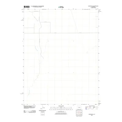
2010 Map of Hanover SE
USGS Topo · Published 2010About this map
Black Squirrel Creek defines the western corridor of this high plains landscape in El Paso County, carving a seasonal drainage path through the open terrain. This 2010 survey shows a sparse network of section roads that maintain the region's agricultural and rural character, with S Squirrel Creek Rd and Squirrel Creek Pl providing primary access to the drainage area. The rectangular grid of Myers Rd and Dearing Rd reflects the enduring land partitions of the eastern Colorado plains, where large-scale ranching or dryland farming operations typically dictate the placement of local infrastructure and private holdings.
Find a feature on this map
5 named features on this map. Tap any name to fly to it.
Don’t see what you’re looking for? This feature index may not catch every label — zoom into the map to look around manually.
Map Details
Editions of this 2010 Hanover SE Map
This is the sole edition of this map. No revisions or reprints were ever made.
Other maps of this area

1891 · Nepesta
USGS Topo · 1:125,000

1893 · Nepesta
USGS Topo · 1:125,000

1893 · Big Springs
USGS Topo · 1:125,000

1904 · Nepesta
USGS Topo · 1:125,000
1954 · Hanover NW
USGS Topo · 1:24,000
1954 · Hanover
USGS Topo · 1:24,000

1954 · Pueblo
USGS Topo · 1:250,000

1957 · Pueblo
USGS Topo · 1:250,000

1958 · Pueblo
USGS Topo · 1:250,000

1959 · Highlands Church
USGS Topo · 1:24,000