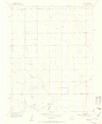
1954 Map of Hanover
USGS Topo · Published 1955About this map
Hanover School and the nearby Hanover Church serve as the focal points for this rural community on the high plains of southern Colorado. The landscape in the mid-1950s is defined by a series of family ranching operations, including Reble Ranch, Appelt Jr. Ranch, and Finch Ranch. Water management is central to life here, evidenced by Smith Reservoir and several check dams situated to capture seasonal runoff. The terrain is deeply etched by the drainage of Chico Creek, which flows southward across the boundary between El Paso and Pueblo counties. While Hanover Road provides a primary east-west corridor, the area is largely traversed by a network of jeep trails and ranch roads, reflecting the sparse, utilitarian nature of the settlement pattern during this era.
Find a feature on this map
17 named features on this map. Tap any name to fly to it.
Don’t see what you’re looking for? This feature index may not catch every label — zoom into the map to look around manually.
Map Details
Editions of this 1954 Hanover Map
3 editions found
Other maps of this area

1891 · Pueblo
USGS Topo · 1:125,000

1891 · Nepesta
USGS Topo · 1:125,000

1893 · Nepesta
USGS Topo · 1:125,000

1893 · Big Springs
USGS Topo · 1:125,000

1893 · Colorado Springs
USGS Topo · 1:125,000

1894 · Pueblo
USGS Topo · 1:125,000

1896 · Pueblo
USGS Topo · 1:125,000

1897 · Pueblo
USGS Topo · 1:125,000

1904 · Nepesta
USGS Topo · 1:125,000

1909 · Colorado Springs
USGS Topo · 1:125,000