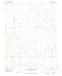
1954 Map of Hanover
USGS Topo · Published 1974About this map
The high plains south of Colorado Springs are defined here by a network of ranching operations and water management along Chico Creek. These mid-century landscapes were mapped in 1952 and field-checked in 1954, capturing a pastoral era when family-named properties like Reble Ranch, Appelt Jr Ranch, and Finch Ranch anchored the rural economy. Settlement is concentrated along Hanover Road, where community life centered on the Hanover Sch, Hanover Ch, and the nearby Hanover Cem. The reliance on water in this semi-arid region is evident through the engineered Hanover Ditch, the Smith Reservoir, and numerous windmills scattered across the township lines. A small Airstrip and several miles of Jeep Trails provide a look at the remote transportation methods used by ranchers and land managers as the El Paso and Pueblo county line was surveyed.
Find a feature on this map
19 named features on this map. Tap any name to fly to it.
Don’t see what you’re looking for? This feature index may not catch every label — zoom into the map to look around manually.
Map Details
Editions of this 1954 Hanover Map
3 editions found
Other maps of this area

1891 · Pueblo
USGS Topo · 1:125,000

1891 · Nepesta
USGS Topo · 1:125,000

1893 · Nepesta
USGS Topo · 1:125,000

1893 · Big Springs
USGS Topo · 1:125,000

1893 · Colorado Springs
USGS Topo · 1:125,000

1894 · Pueblo
USGS Topo · 1:125,000

1896 · Pueblo
USGS Topo · 1:125,000

1897 · Pueblo
USGS Topo · 1:125,000

1904 · Nepesta
USGS Topo · 1:125,000

1909 · Colorado Springs
USGS Topo · 1:125,000