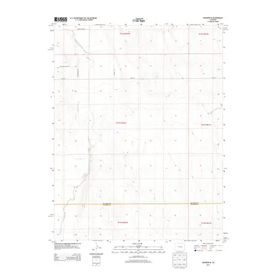
2013 Map of Hanover SE
USGS Topo · Published 2013About this map
The high plains terrain of southeastern Colorado is defined by the ephemeral path of Black Squirrel Cr, which meanders south toward the border between El Paso and Pueblo counties. This 2013 survey reveals a landscape organized by the Public Land Survey System, where modern rural development is traced along grid-aligned corridors like Myers Rd and Dearing Rd. The northern portion of the quadrangle shows the emergence of residential clusters near Squirrel Creek Pl, Mountain Prairie Dr, and Meadowbrook Grv. The mapping of these townships—including T016S, T017S, and T018S across ranges R061W and R062W—illustrates the transition of former ranchlands into a more subdivided rural residential character just north of the Pueblo County line.
Find a feature on this map
13 named features on this map. Tap any name to fly to it.
Don’t see what you’re looking for? This feature index may not catch every label — zoom into the map to look around manually.
Map Details
Editions of this 2013 Hanover SE Map
This is the sole edition of this map. No revisions or reprints were ever made.
Other maps of this area

1891 · Nepesta
USGS Topo · 1:125,000

1893 · Nepesta
USGS Topo · 1:125,000

1893 · Big Springs
USGS Topo · 1:125,000

1904 · Nepesta
USGS Topo · 1:125,000
1954 · Hanover NW
USGS Topo · 1:24,000
1954 · Hanover
USGS Topo · 1:24,000

1954 · Pueblo
USGS Topo · 1:250,000

1957 · Pueblo
USGS Topo · 1:250,000

1958 · Pueblo
USGS Topo · 1:250,000

1959 · Highlands Church
USGS Topo · 1:24,000