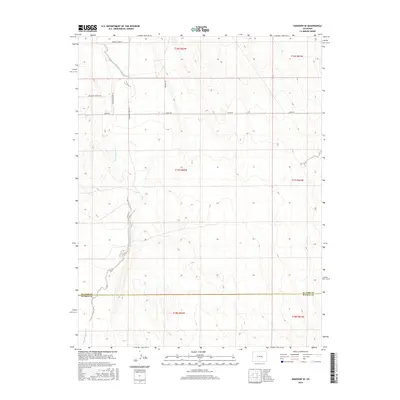
2016 Map of Hanover SE
USGS Topo · Published 2016About this map
Black Squirrel Cr meanders through this high-plains landscape southeast of Colorado Springs, defining the drainage patterns across a largely undeveloped expanse of El Paso and Pueblo counties. The map captures the area as it appeared in the mid-2010s, showing a transition from open rangeland to early rural residential development. While much of the terrain is defined by its natural topography, a sparse network of roads like Myers Rd and Squirrel Creek Rd provide access to the interior. The presence of newer residential naming conventions, such as Mountain Prairie Dr and Meadow Brook Dr, suggests a shifting land use toward small-acreage homesteads. This detailed survey preserves the precise alignment of the El Paso and Pueblo county line as it bisects the sections of Townships 17 and 18 South.
Find a feature on this map
14 named features on this map. Tap any name to fly to it.
Don’t see what you’re looking for? This feature index may not catch every label — zoom into the map to look around manually.
Map Details
Editions of this 2016 Hanover SE Map
This is the sole edition of this map. No revisions or reprints were ever made.
Other maps of this area

1891 · Nepesta
USGS Topo · 1:125,000

1893 · Nepesta
USGS Topo · 1:125,000

1893 · Big Springs
USGS Topo · 1:125,000

1904 · Nepesta
USGS Topo · 1:125,000
1954 · Hanover NW
USGS Topo · 1:24,000
1954 · Hanover
USGS Topo · 1:24,000

1954 · Pueblo
USGS Topo · 1:250,000

1957 · Pueblo
USGS Topo · 1:250,000

1958 · Pueblo
USGS Topo · 1:250,000

1959 · Highlands Church
USGS Topo · 1:24,000