
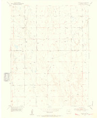
1973 Map of Hanover SE
USGS Topo · Published 1975About this map
Black Squirrel Creek meanders through this arid landscape of the Colorado high plains, defining the topography of a region at the intersection of traditional ranching and modern federal research. The northern section of the map preserves a rural character focused around Squirrel Creek School and cattle-country infrastructure like the Dearing Road and Myers Road. This agricultural tradition meets the industrial future at the El Paso Co Pueblo Co line.
Find a feature on this map
14 named features on this map. Tap any name to fly to it.
Don’t see what you’re looking for? This feature index may not catch every label — zoom into the map to look around manually.
Map Details
Editions of this 1973 Hanover SE Map
This is the sole edition of this map. No revisions or reprints were ever made.
Other maps of this area

1891 · Nepesta
USGS Topo · 1:125,000

1893 · Nepesta
USGS Topo · 1:125,000

1893 · Big Springs
USGS Topo · 1:125,000
1904 · Nepesta
USGS Topo · 1:125,000
1954 · Hanover NW
USGS Topo · 1:24,000
1954 · Hanover
USGS Topo · 1:24,000

1954 · Pueblo
USGS Topo · 1:250,000

1957 · Pueblo
USGS Topo · 1:250,000

1958 · Pueblo
USGS Topo · 1:250,000
1959 · Highlands Church
USGS Topo · 1:24,000