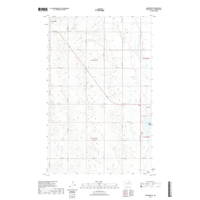
2017 Map of Hansboro SE
USGS Topo · Published 2017About this map
Amourdale sits in the northwestern corner of this Towner County landscape, an area defined by the subtle drainage patterns of the northern prairie. The map documents a sparsely populated agricultural region where the natural hydrology remains a dominant feature, specifically through the presence of Big Coulee and Mauvais Coulee. These coulees, along with Rock Lake on the eastern edge, dictate the placement of the section-line road grid, which includes routes from 100th St NE down to 93rd St NE. One of the most significant points for local history is the All Nations Cem located near the eastern boundary. This 2017 survey reflects the persistent rural character of North Dakota, preserving the precise township and range divisions such as t162n r67w and t161n r66w that have organized this landscape since the early days of settlement.
Find a feature on this map
18 named features on this map. Tap any name to fly to it.
Don’t see what you’re looking for? This feature index may not catch every label — zoom into the map to look around manually.
Map Details
Editions of this 2017 Hansboro SE Map
This is the sole edition of this map. No revisions or reprints were ever made.
Other maps of this area

1953 · Devils Lake
USGS Topo · 1:250,000

1956 · Devils Lake
USGS Topo · 1:250,000

1962 · Snyder Lake
USGS Topo · 1:24,000
1969 · Hansboro NE
USGS Topo · 1:24,000
1969 · Hansboro
USGS Topo · 1:24,000
1969 · Rock Lake NW
USGS Topo · 1:24,000

1970 · Hansboro SW
USGS Topo · 1:24,000

1970 · Hansboro SE
USGS Topo · 1:24,000

1970 · Rock Lake
USGS Topo · 1:24,000

1971 · Bisbee North
USGS Topo · 1:24,000