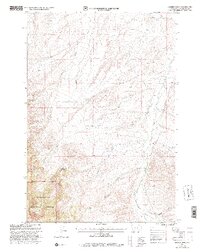
1997 Map of Hansen Ranch
USGS Topo · Published 2002About this map
Beaverhead National Forest defines the southwestern terrain of this 1990s-era study, where the Dillon Ranger District oversees a landscape carved by numerous drainage systems. The namesake Hansen Ranch sits as a primary point of human settlement, positioned near the confluence of local tributaries. Water management is a visible priority in this high-elevation environment, evidenced by the Payment Ditch in the north and the complex network of creeks including Medicine Lodge Creek, Barrett Creek, and Poole Creek. The map documents the physical geography of the Second Standard Parallel South, showing how canyon formations like Baker Canyon and Kissick Canyon dictate the path of light-duty and unimproved roads. This topographic record captures the area's transition into the late 20th century, balancing natural forest land with isolated ranching operations.
Find a feature on this map
14 named features on this map. Tap any name to fly to it.
Don’t see what you’re looking for? This feature index may not catch every label — zoom into the map to look around manually.
Map Details
Editions of this 1997 Hansen Ranch Map
This is the sole edition of this map. No revisions or reprints were ever made.
Other maps of this area

1893 · Dillon
USGS Topo · 1:250,000

1952 · Eli Spring
USGS Topo · 1:24,000

1955 · Dubois
USGS Topo · 1:250,000

1955 · Dillon
USGS Topo · 1:250,000

1957 · Dillon
USGS Topo · 1:250,000

1958 · Dubois
USGS Topo · 1:250,000

1958 · Dillon
USGS Topo · 1:250,000

1959 · Grant
USGS Topo · 1:62,500

1962 · Dillon
USGS Topo · 1:250,000
1965 · Garfield Canyon
USGS Topo · 1:24,000