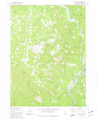
1980 Map of Happy Camp
USGS Topo · Published 1981About this map
The Klamath River flows through this 1980 survey, serving as the central artery for the mountain settlement of Happy Camp. Located within the Klamath National Forest, the area is defined by sharp elevation changes, from the riverbank flats like Deason Flat up to the high peaks of Baldy Mountain Ridge. The infrastructure of the era is clearly marked, including the Happy Camp Airport, a Substation, and a Gaging Station along Indian Creek. Remote outposts such as Beans Camp and a Lookout Tower near Baldy Mtn point to the forest management and recreational patterns of the late 20th century. Numerous named drainages, including Elk Creek, Titus Creek, and Doolittle Creek, illustrate the complex hydrology of this Siskiyou County landscape. Smaller details like a Prospect in the northeast and various 4 WD roads provide clues for those tracing local land use and resource exploration.
Find a feature on this map
43 named features on this map. Tap any name to fly to it.
Don’t see what you’re looking for? This feature index may not catch every label — zoom into the map to look around manually.
Map Details
Editions of this 1980 Happy Camp Map
This is the sole edition of this map. No revisions or reprints were ever made.
Other maps of this area

1914 · Seiad
USGS Topo · 1:125,000

1922 · Preston Peak
USGS Topo · 1:125,000

1922 · Seiad
USGS Topo · 1:125,000

1948 · Weed
USGS Topo · 1:250,000

1950 · Weed
USGS Topo · 1:250,000

1955 · Dillon Mtn
USGS Topo · 1:62,500

1955 · Ukonom Lake
USGS Topo · 1:62,500

1956 · Happy Camp
USGS Topo · 1:62,500

1956 · Preston Peak
USGS Topo · 1:62,500

1958 · Weed
USGS Topo · 1:250,000