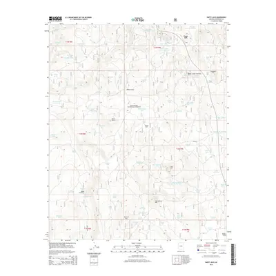
2014 Map of Happy Jack
USGS Topo · Published 2014About this map
Happy Jack serves as the primary settlement hub for this high-altitude landscape within the Coconino National Forest. The 2014 survey reveals an intricate system of water management essential for forest health and livestock, characterized by numerous named tanks and springs. Prominent landmarks such as Buck Mountain and Hollingshead Mtn define the topography, while wide grazing or clearing areas like Casner Park and Mahan Park suggest the land's multi-use history. The infrastructure for resource extraction is evident in features like Borrow Pit Number Two Tank and Borrow Pit Number Three Tank, alongside a network of forest service routes including Fire Rd 229. Geologists and researchers can trace the drainage patterns through Brady Canyon and the Sheep Tank Draw, which weave between distinct volcanic-named peaks like Landmark Mtn.
Find a feature on this map
76 named features on this map. Tap any name to fly to it.
Don’t see what you’re looking for? This feature index may not catch every label — zoom into the map to look around manually.
Map Details
Editions of this 2014 Happy Jack Map
This is the sole edition of this map. No revisions or reprints were ever made.
Other maps of this area

1887 · Verde
USGS Topo · 1:250,000

1892 · Verde
USGS Topo · 1:250,000

1923 · Camp Verde
USGS Topo · 1:125,000

1932 · Camp Verde
USGS Topo · 1:125,000

1936 · Camp Verde
USGS Topo · 1:125,000

1954 · Holbrook
USGS Topo · 1:250,000

1957 · Holbrook
USGS Topo · 1:250,000

1958 · Holbrook
USGS Topo · 1:250,000

1960 · Holbrook
USGS Topo · 1:250,000
1965 · Long Valley
USGS Topo · 1:24,000