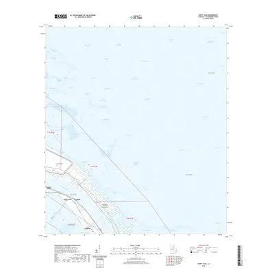
2020 Map of Happy Jack
USGS Topo · Published 2020About this map
Mississippi River silt and marshlands define this coastal landscape in Plaquemines Parish, where a thin ribbon of habitable land clings to the river's western bank. The settlements of Happy Jack, Encalade, and Port Sulphur are anchored along Levee Rd and River Rd, reflecting the traditional linear development patterns of south Louisiana. This recent survey illustrates the critical water management infrastructure necessary for this environment, including the Pointe A La Hache Relief Outlet and the Back Levee Canal. Beyond the levee system, the map reveals a complex web of estuaries and inlets such as American Bay, Black Bay, and Bay Gardene. These wetlands are crisscrossed by numerous waterways like William Boyles Bayou and Francis Martin Bayou, while the presence of the Bohemian Cem near Point Michel offers a point of interest for those tracing local family histories in this shifting delta region.
Find a feature on this map
62 named features on this map. Tap any name to fly to it.
Don’t see what you’re looking for? This feature index may not catch every label — zoom into the map to look around manually.
Map Details
Editions of this 2020 Happy Jack Map
This is the sole edition of this map. No revisions or reprints were ever made.
Other maps of this area

1891 · Pointe a La Hache
USGS Topo · 1:62,500

1892 · Quarantine
USGS Topo · 1:62,500

1892 · Pointe a La Hache
USGS Topo · 1:62,500

1893 · Fort Livingston
USGS Topo · 1:62,500

1893 · Dime
USGS Topo · 1:62,500

1935 · Port Sulphur
USGS Topo · 1:31,680

1935 · Lake Calebasse
USGS Topo · 1:31,680

1935 · Lake Batola
USGS Topo · 1:31,680

1935 · Tropical Bend
USGS Topo · 1:31,680

1939 · Pointe a La Hache
USGS Topo · 1:62,500