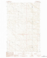
1984 Map of Harb SW
USGS Topo · Published 1984About this map
The high plains along the Phillips Co and Valley Co border are defined by an intricate network of drainage channels in this mid-1980s topographic study. The landscape is characterized by its named coulees, including Windmill Coulee, Pickhandle Coulee, and Black Coulee, which serve as the primary geographical markers in this sparsely populated territory. Larb Creek cuts through the southeastern corner, while the presence of Grove Coulee and Grandpa Coulee suggests a history of local naming conventions tied to family homesteads or specific landmarks. This provisional survey captures the elevation and drainage patterns of the Montana prairie before modern digital mapping, providing a clear view of the section lines and terrain that governed land use in this part of the state.
Find a feature on this map
7 named features on this map. Tap any name to fly to it.
Don’t see what you’re looking for? This feature index may not catch every label — zoom into the map to look around manually.
Map Details
Editions of this 1984 Harb SW Map
This is the sole edition of this map. No revisions or reprints were ever made.
Other maps of this area

1954 · Jordan
USGS Topo · 1:250,000

1954 · Glasgow
USGS Topo · 1:250,000

1956 · Jordan
USGS Topo · 1:250,000

1957 · Glasgow
USGS Topo · 1:250,000

1958 · Glasgow
USGS Topo · 1:250,000

1958 · Jordan
USGS Topo · 1:250,000

1964 · Jordan
USGS Topo · 1:250,000

1965 · Buckley Lake
USGS Topo · 1:24,000

1973 · Niles Coulee
USGS Topo · 1:24,000
1973 · White Horse Coulee
USGS Topo · 1:24,000