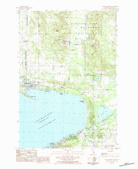
1983 Map of Harbor Springs
USGS Topo · Published 1984About this map
Harbor Springs and the surrounding townships along Little Traverse Bay define this 1983 topographic study. The landscape transitions from the developed waterfront at Wequetonsing to the recreational highlands of the Boyne Highlands Ski Area and Nubs Nob Ski Area. Local history and genealogy interests are well-served by the presence of Lakeview Cem, Graham Chapel, and the Shay Sch near the town center. The map details a varied economic and leisure environment, from the Boyne Highlands Landing Strip and multiple golf courses to the industrial footprint of a Gravel Pit near Round Lake. Much of the northern interior is dominated by the Mackinaw State Forest, while the southern shoreline connects through Bay View toward the edge of Petoskey.
Find a feature on this map
49 named features on this map. Tap any name to fly to it.
Don’t see what you’re looking for? This feature index may not catch every label — zoom into the map to look around manually.
Map Details
Editions of this 1983 Harbor Springs Map
This is the sole edition of this map. No revisions or reprints were ever made.
Other maps of this area

1955 · Cheboygan
USGS Topo · 1:250,000

1958 · Cheboygan
USGS Topo · 1:250,000

1958 · Cross Village
USGS Topo · 1:62,500

1958 · Pellston
USGS Topo · 1:62,500

1958 · Bayshore
USGS Topo · 1:62,500

1958 · Petoskey
USGS Topo · 1:62,500

1975 · Petoskey NW
USGS Topo · 1:24,000

1975 · Petoskey SW
USGS Topo · 1:24,000

1975 · Petoskey NE
USGS Topo · 1:24,000

1982 · Petoskey
USGS Topo · 1:100,000