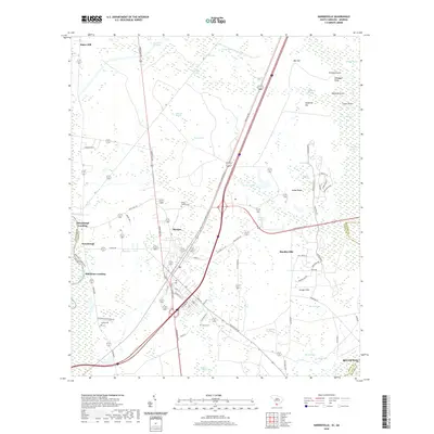
2020 Map of Hardeeville
USGS Topo · Published 2020About this map
Purysburgh sits on the eastern bank of the Savannah River at the South Carolina and Georgia state line, a location deeply tied to the river's transport history. The landscape is defined by its extensive wetland network, where drainage basins like Fourmile Swamp, Sixmile Swamp, and Brickyard Swamp wind between sandy elevations such as Sassafras Hill and Calabash Knoll. The town of Hardeeville serves as a central hub, where modern road development like General William Hardee Blvd and Speedway Blvd intersects with older routes. Genealogists will find several burial sites noted, including White Hardee Cem, Pelote Cem, and Sancie Cem. This 2020 record reflects the coexistence of low-country wetlands and the expanding suburban corridors of Jasper and Beaufort counties, reaching toward the Bluffton area in the southeast.
Find a feature on this map
83 named features on this map. Tap any name to fly to it.
Don’t see what you’re looking for? This feature index may not catch every label — zoom into the map to look around manually.
Map Details
Editions of this 2020 Hardeeville Map
This is the sole edition of this map. No revisions or reprints were ever made.
Other maps of this area

1920 · Hardeeville
USGS Topo · 1:62,500

1920 · Okatie
USGS Topo · 1:62,500

1920 · Bluffton
USGS Topo · 1:62,500

1942 · Savannah
USGS Topo · 1:62,500

1942 · Okatie
USGS Topo · 1:62,500

1943 · Hardeeville
USGS Topo · 1:62,500

1945 · Bluffton
USGS Topo · 1:62,500

1947 · Savannah
USGS Topo · 1:250,000

1948 · Savannah
USGS Topo · 1:250,000

1953 · Hardeeville
USGS Topo · 1:62,500