
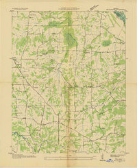
1936 Map of Hardin
USGS Topo · Published 1936About this map
The Benton and Hardin area of Marshall County is shown here during a period of significant infrastructure development under the Tennessee Valley Authority. The Nashville Chattanooga and St Louis Ry runs north-south, paralleling the Jefferson Davis Highway and providing the primary transport spine for these agricultural communities. A distinct local landmark of the New Deal era, CCC Camp No 508, sits just west of Benton, reflecting the federal investment in the region's landscape during the 1930s.
Find a feature on this map
65 named features on this map. Tap any name to fly to it.
Don’t see what you’re looking for? This feature index may not catch every label — zoom into the map to look around manually.
Map Details
Editions of this 1936 Hardin Map
This is the sole edition of this map. No revisions or reprints were ever made.
Other maps of this area

1936 · Oak Level
USGS Topo · 1:24,000

1936 · Elva
USGS Topo · 1:24,000

1936 · Hiatt
USGS Topo · 1:24,000

1936 · Benton
USGS Topo · 1:48,000

1936 · Birmingham
USGS Topo · 1:24,000

1936 · Golden Pond
USGS Topo · 1:48,000

1936 · Dexter
USGS Topo · 1:24,000

1936 · Hico
USGS Topo · 1:24,000

1936 · Kirksey
USGS Topo · 1:24,000
1936 · Briensburg
USGS Topo · 1:24,000