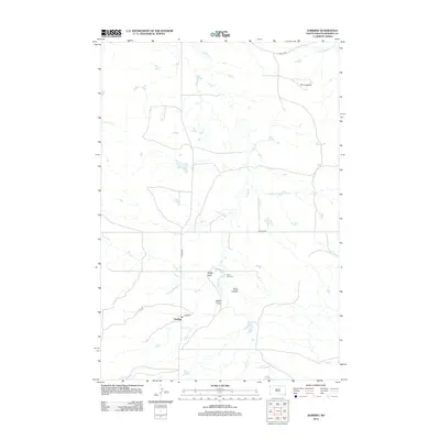
2012 Map of Harding
USGS Topo · Published 2012About this map
Harding serves as the central settlement in this high plains landscape of northwestern South Dakota, situated at the intersection of Co HWY s97 and local routes like Mackey RD. The geography is defined by a dendritic drainage pattern where Valley Cr, Waterhole Cr, and Brush Cr flow toward the Little Grand River in the northeast corner. This 2012 survey illustrates the sparse but distinct ranching infrastructure of the region, marked by named features like Dodge Draw, Sand Coulee, and Gilbert Draw. Local history is anchored at the Short Pine Cem, while the dramatic terrain of The Jumpoff stands out as a significant landmark in the eastern portion of the quadrangle. The map captures a moment in the early 21st century when these remote rural communities and their associated landforms remained largely unchanged from earlier eras of western settlement.
Find a feature on this map
14 named features on this map. Tap any name to fly to it.
Don’t see what you’re looking for? This feature index may not catch every label — zoom into the map to look around manually.
Map Details
Editions of this 2012 Harding Map
This is the sole edition of this map. No revisions or reprints were ever made.
Other maps of this area

1935 · Harding
USGS Topo · 1:125,000

1935 · Buffalo
USGS Topo · 1:125,000

1954 · Lemmon
USGS Topo · 1:250,000

1957 · Lemmon
USGS Topo · 1:250,000

1971 · Saddle Butte
USGS Topo · 1:24,000

1973 · Bog Creek
USGS Topo · 1:24,000

1973 · Hells Canyon
USGS Topo · 1:24,000

1974 · Pine Spring
USGS Topo · 1:24,000
1977 · Harding
USGS Topo · 1:24,000
1977 · Camp Crook
USGS Topo · 1:24,000