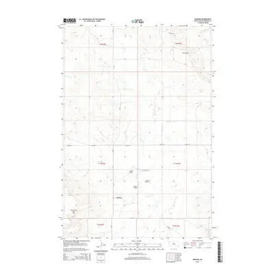
2015 Map of Harding
USGS Topo · Published 2015About this map
Harding stands as the primary settlement in this corner of Harding County, situated near the western edge of the West Short Pine Hills. The landscape is defined by its drainage systems and distinct topographic breaks, most notably The Jumpoff in the northeast and the seasonal flow of the Little Grand River. A network of rural routes like CR-897 and Mackey Rd connects isolated homesteads and local landmarks such as the Short Pine Cem. The terrain is deeply etched by numerous draws and coulees, including Dodge Draw, Gilbert Draw, and Sand Coulee, which channel runoff toward Valley Cr. This drainage pattern reflects a high-plains environment where water management and ranching navigation are central to the local geography.
Find a feature on this map
22 named features on this map. Tap any name to fly to it.
Don’t see what you’re looking for? This feature index may not catch every label — zoom into the map to look around manually.
Map Details
Editions of this 2015 Harding Map
This is the sole edition of this map. No revisions or reprints were ever made.
Other maps of this area

1935 · Harding
USGS Topo · 1:125,000

1935 · Buffalo
USGS Topo · 1:125,000

1954 · Lemmon
USGS Topo · 1:250,000

1957 · Lemmon
USGS Topo · 1:250,000

1971 · Saddle Butte
USGS Topo · 1:24,000

1973 · Bog Creek
USGS Topo · 1:24,000

1973 · Hells Canyon
USGS Topo · 1:24,000

1974 · Pine Spring
USGS Topo · 1:24,000
1977 · Harding
USGS Topo · 1:24,000
1977 · Camp Crook
USGS Topo · 1:24,000