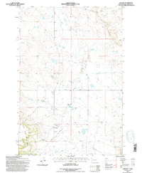
1993 Map of Harding
USGS Topo · Published 1996About this map
Harding occupies a prominent position in this northwestern South Dakota landscape, situated just north of the dramatic rising slopes of the West Short Pine Hills. The map details a cattle-country environment where ephemeral watercourses like Dodge Draw, Waterhole Creek, and Sand Coulee carve through the plains. To the north, the terrain drops away at the escarpment known as The Jump Off, leading toward the drainage of the Grand River. Evidence of local community life is preserved through labels for the Brant School and the Short Pine Cem, while the local transportation network is anchored by Hett-Gilbert Road and Mackey Road. This 1993 revision, based on earlier aerial photography, provides a clear view of the rural infrastructure, including a Landing Strip and a Gravel Pit, typical of the area's late-twentieth-century land use.
Find a feature on this map
16 named features on this map. Tap any name to fly to it.
Don’t see what you’re looking for? This feature index may not catch every label — zoom into the map to look around manually.
Map Details
Editions of this 1993 Harding Map
This is the sole edition of this map. No revisions or reprints were ever made.
Other maps of this area

1935 · Harding
USGS Topo · 1:125,000

1935 · Buffalo
USGS Topo · 1:125,000

1954 · Lemmon
USGS Topo · 1:250,000

1957 · Lemmon
USGS Topo · 1:250,000

1971 · Saddle Butte
USGS Topo · 1:24,000

1973 · Bog Creek
USGS Topo · 1:24,000

1973 · Hells Canyon
USGS Topo · 1:24,000

1974 · Pine Spring
USGS Topo · 1:24,000
1977 · Harding
USGS Topo · 1:24,000
1977 · Camp Crook
USGS Topo · 1:24,000