
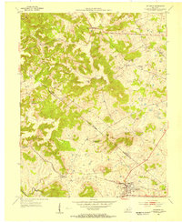
1947 Map of Hardinsburg
USGS Topo · Published 1947About this map
Hardinsburg serves as the central hub of this 1947 survey, where the local road network converges at the county seat. The landscape is defined by the winding course of Sinking Creek and the deep incisions of Miller Hollow and Norton Valley. Evidence of changing transportation infrastructure is visible in the Dismantled Railroad that once connected these rural communities to broader markets.
Find a feature on this map
18 named features on this map. Tap any name to fly to it.
Don’t see what you’re looking for? This feature index may not catch every label — zoom into the map to look around manually.
Map Details
Editions of this 1947 Hardinsburg Map
This is the sole edition of this map. No revisions or reprints were ever made.
Other maps of this area

1928 · Hardinsburg
USGS Topo · 1:48,000

1931 · Hardinsburg
USGS Topo · 1:62,500

1932 · Fordsville
USGS Topo · 1:62,500

1934 · Cannelton
USGS Topo · 1:62,500

1947 · Irvington
USGS Topo · 1:24,000

1947 · Lodiburg
USGS Topo · 1:24,000

1947 · Garfield
USGS Topo · 1:24,000

1947 · Hardinsburg
USGS Topo · 1:62,500

1953 · Custer
USGS Topo · 1:24,000
1953 · Irvington
USGS Topo · 1:24,000