
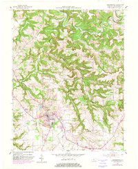
1953 Map of Hardinsburg
USGS Topo · Published 1954About this map
Hardinsburg serves as the focal point of this 1950s survey, showing the county seat's mid-century layout complete with its Waterworks, Reservoir, and Fairgrounds. The surrounding landscape of Breckinridge County is defined by the winding course of Sinking Creek and the intricate ridges of Norton Valley and Dorridge. Rural life is meticulously documented through a network of country schools and churches, such as Norton Valley Sch, Bells Sch, and Horsley Chapel, reflecting a dispersed settlement pattern typical of the era.
Find a feature on this map
35 named features on this map. Tap any name to fly to it.
Don’t see what you’re looking for? This feature index may not catch every label — zoom into the map to look around manually.
Map Details
Editions of this 1953 Hardinsburg Map
2 editions found
Other maps of this area

1928 · Hardinsburg
USGS Topo · 1:48,000

1931 · Hardinsburg
USGS Topo · 1:62,500

1932 · Fordsville
USGS Topo · 1:62,500

1934 · Cannelton
USGS Topo · 1:62,500

1947 · Irvington
USGS Topo · 1:24,000

1947 · Lodiburg
USGS Topo · 1:24,000

1947 · Hardinsburg
USGS Topo · 1:24,000

1947 · Garfield
USGS Topo · 1:24,000

1947 · Hardinsburg
USGS Topo · 1:62,500

1953 · Custer
USGS Topo · 1:24,000