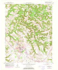
1953 Map of Hardinsburg
USGS Topo · Published 1982About this map
Hardinsburg serves as the focal point of this mid-century topographic record, situated at the junction of critical local transit routes and the Hardins Creek valley. The map reveals a community defined by its rural institutions, with rural congregations at Horsley Chapel, Friendship Ch, and Ephesus Ch anchoring the surrounding countryside. Educational and civic infrastructure is prominently mapped, including the St Romuald Sch and the County Airport situated just east of the primary settlement.
Find a feature on this map
34 named features on this map. Tap any name to fly to it.
Don’t see what you’re looking for? This feature index may not catch every label — zoom into the map to look around manually.
Map Details
Editions of this 1953 Hardinsburg Map
2 editions found

Other maps of this area

1928 · Hardinsburg
USGS Topo · 1:48,000

1931 · Hardinsburg
USGS Topo · 1:62,500

1932 · Fordsville
USGS Topo · 1:62,500

1934 · Cannelton
USGS Topo · 1:62,500

1947 · Irvington
USGS Topo · 1:24,000

1947 · Lodiburg
USGS Topo · 1:24,000

1947 · Hardinsburg
USGS Topo · 1:24,000

1947 · Garfield
USGS Topo · 1:24,000

1947 · Hardinsburg
USGS Topo · 1:62,500

1953 · Custer
USGS Topo · 1:24,000