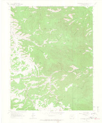
1963 Map of Hardscrabble Mountain
USGS Topo · Published 1965About this map
San Isabel National Forest dominates this mid-century landscape in Custer County, defined by a complex network of ridges and drainages. The settlement of Ilse and the Silver Park Sch reflect the small-scale infrastructure of the period, while McKenzie Junction marks a key intersection on State Route 96. The topography is a labyrinth of gulches, including Rattlesnake Gulch, Watson Gulch, and Bear Gulch, which funnel into North Hardscrabble Creek. These drainage patterns, coupled with landmarks like Hardscrabble Mountain and Lead Mountain, reveal the difficult access and isolated nature of the terrain. The presence of the Highline Trail and several pack trails highlights the area's history of recreation and forest management, while a lone Gravel Pit and the Smith Creek Campground indicate localized industry and leisure use in the early 1960s.
Find a feature on this map
44 named features on this map. Tap any name to fly to it.
Don’t see what you’re looking for? This feature index may not catch every label — zoom into the map to look around manually.
Map Details
Editions of this 1963 Hardscrabble Mountain Map
3 editions found
Other maps of this area

1889 · Canon City
USGS Topo · 1:125,000

1892 · Canon City
USGS Topo · 1:125,000

1954 · Mount Tyndall
USGS Topo · 1:24,000

1954 · Rosita
USGS Topo · 1:24,000

1954 · Pueblo
USGS Topo · 1:250,000

1957 · Pueblo
USGS Topo · 1:250,000

1958 · Pueblo
USGS Topo · 1:250,000

1959 · Rockvale
USGS Topo · 1:24,000

1959 · Royal Gorge
USGS Topo · 1:62,500
1959 · Florence SE
USGS Topo · 1:24,000