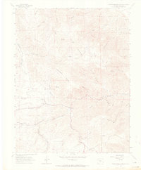
1963 Map of Hardscrabble Mountain
USGS Topo · Published 1965About this map
Hardscrabble Mountain dominates the central landscape of this 1963 survey, where the complex drainage systems of the San Isabel National Forest converge. The area is defined by a network of gulches and creeks, including North Fork Hardscrabble Creek and Silver Park Creek, which carve through high elevations marked by Adobe Peak and Lead Mountain. This era captures a transition from early extraction and education toward recreation, shown by the location of the Silver Park Sch near the settlement of Ilse and the development of the Smith Creek Campground.
Find a feature on this map
46 named features on this map. Tap any name to fly to it.
Don’t see what you’re looking for? This feature index may not catch every label — zoom into the map to look around manually.
Map Details
Editions of this 1963 Hardscrabble Mountain Map
3 editions found
Other maps of this area

1889 · Canon City
USGS Topo · 1:125,000

1892 · Canon City
USGS Topo · 1:125,000

1954 · Mount Tyndall
USGS Topo · 1:24,000

1954 · Rosita
USGS Topo · 1:24,000

1954 · Pueblo
USGS Topo · 1:250,000

1957 · Pueblo
USGS Topo · 1:250,000

1958 · Pueblo
USGS Topo · 1:250,000

1959 · Rockvale
USGS Topo · 1:24,000

1959 · Royal Gorge
USGS Topo · 1:62,500
1959 · Florence SE
USGS Topo · 1:24,000