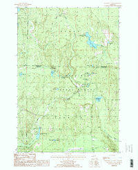
1986 Map of Hardwood Lake
USGS Topo · Published 1986About this map
Pigeon River Country State Forest dominates this northern Michigan landscape, where the Pigeon River and Black River systems carve through dense forest land. This mid-1980s survey captures a wilderness managed for both recreation and resource protection, marked by the extensive High Country Pathway and numerous public campgrounds. An Old Railroad Grade in the northeast corner serves as a relic of the region's earlier industrial timber era, while the Cornwall Creek Flooding illustrates the intentional management of water levels for local ecology. Notable landmarks include the Paul Bunyan Punch Bowl, a distinct terrain feature, and a collection of specialized water bodies such as Lansing Club Pond, Hardwood L, and the Twin Lakes. The boundary between Cheboygan Co and Otsego Co bisects the map, showing the division of these remote forest tracts.
Find a feature on this map
29 named features on this map. Tap any name to fly to it.
Don’t see what you’re looking for? This feature index may not catch every label — zoom into the map to look around manually.
Map Details
Editions of this 1986 Hardwood Lake Map
2 editions found
Other maps of this area

1954 · Gaylord
USGS Topo · 1:62,500

1954 · Hetherton
USGS Topo · 1:62,500

1955 · Cheboygan
USGS Topo · 1:250,000

1957 · Tower
USGS Topo · 1:62,500

1957 · Wolverine
USGS Topo · 1:62,500

1958 · Cheboygan
USGS Topo · 1:250,000

1982 · Petoskey
USGS Topo · 1:100,000

1986 · Silver Lake
USGS Topo · 1:24,000
1986 · Saunders Creek
USGS Topo · 1:24,000
1986 · Tower
USGS Topo · 1:24,000