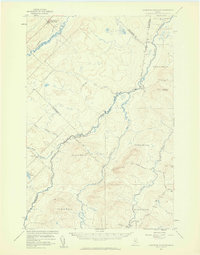
1957 Map of Hardwood Mountain
USGS Topo · Published 1960About this map
The Canada United States border defines the character of this 1957 landscape, where the wilderness of the Somerset County woods meets the organized settlements of Quebec. To the northwest, the Quebec Central Pacific Ry serves the village of St Camille-de-Bellechasse, which stands in contrast to the uninhabited timberlands across the international line. The Maine side is characterized by a network of private logging routes like the Gilbert Private Road and isolated outposts such as Billy Jack Depot.
Find a feature on this map
30 named features on this map. Tap any name to fly to it.
Don’t see what you’re looking for? This feature index may not catch every label — zoom into the map to look around manually.
Map Details
Editions of this 1957 Hardwood Mountain Map
3 editions found
Other maps of this area

1954 · Baker Lake
USGS Topo · 1:62,500

1954 · St. John Pond
USGS Topo · 1:62,500

1954 · Presque Isle
USGS Topo · 1:250,000

1955 · Beaver Pond
USGS Topo · 1:62,500

1957 · Norris Brook
USGS Topo · 1:62,500

1957 · Hardwood Mountain
USGS Topo · 1:62,500

1957 · Saint Zacharie
USGS Topo · 1:62,500

1958 · Presque Isle
USGS Topo · 1:250,000

1958 · Saint John Pond
USGS Topo · 1:62,500

1960 · Presque Isle
USGS Topo · 1:250,000