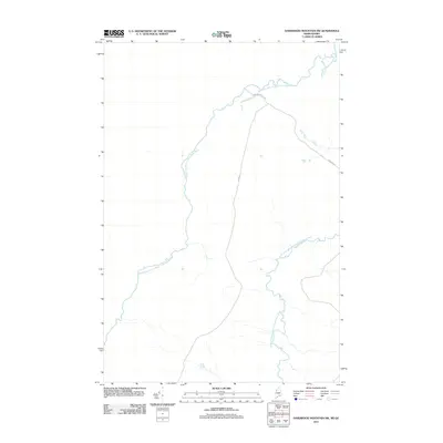
2011 Map of Hardwood Mountain SW
USGS Topo · Published 2011About this map
The Southwest Branch Saint John River defines the landscape of this borderland region, winding through the timberlands and headwaters along the Maine-Quebec frontier. This remote stretch of the North Woods is marked by the confluence of major watercourses, including the Little Southwest Branch Saint John River which feeds into the primary branch from the east. The human imprint on the land is focused almost entirely on the logging and access network, represented by thoroughfares such as Gilbert Rd and Dump Rd. These routes reflect the modern management of this backcountry area, where the vast drainage system of the Saint John River remains the dominant geographic feature, providing a clear view of the hydrological patterns that have shaped the border's development for generations.
Find a feature on this map
4 named features on this map. Tap any name to fly to it.
Don’t see what you’re looking for? This feature index may not catch every label — zoom into the map to look around manually.
Map Details
Editions of this 2011 Hardwood Mountain SW Map
This is the sole edition of this map. No revisions or reprints were ever made.
Other maps of this area

1957 · Norris Brook
USGS Topo · 1:62,500

1957 · Hardwood Mountain
USGS Topo · 1:62,500

1957 · Saint Zacharie
USGS Topo · 1:62,500

1962 · Quebec
USGS Topo · 1:250,000
1986 · Lac Etchemin
USGS Topo · 1:100,000
1989 · Hardwood Mountain
USGS Topo · 1:24,000
1989 · Black Brook
USGS Topo · 1:24,000
1989 · Hardwood Mountain SE
USGS Topo · 1:24,000
1989 · Hinckley Hill
USGS Topo · 1:24,000
1989 · Hardwood Mountain SW
USGS Topo · 1:24,000