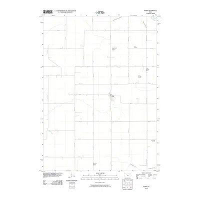
2010 Map of Hardy
USGS Topo · Published 2010About this map
Hardy serves as the quiet center of this Humboldt County township, a landscape defined by its grid-straight section lines and intensive agricultural engineering. The town’s social and historical fabric is anchored by its essential services, including the Hardy Post Office, and several outlying burial grounds like the Swiss Cemetery and Vernon Township Cemetery. The terrain is significantly managed for drainage to support the productive prairie soil, evidenced by the presence of Drainage Ditch No 18 and Drainage Ditch No 9, which channel water away from the expansive fields toward Prairie Creek. Small-scale aviation facilities such as the Brock Ranch Landing Strip and Flying S Ranch Airport reflect the necessity of aerial transit and crop dusting in this rural environment, where family-named landmarks and churches like the Hardy Trinity Lutheran Cemetery provide a sense of local lineage and community continuity.
Find a feature on this map
31 named features on this map. Tap any name to fly to it.
Don’t see what you’re looking for? This feature index may not catch every label — zoom into the map to look around manually.
Map Details
Editions of this 2010 Hardy Map
This is the sole edition of this map. No revisions or reprints were ever made.
Other maps of this area

1923 · Fort Dodge
USGS Topo · 1:62,500

1954 · Waterloo
USGS Topo · 1:250,000

1954 · Fort Dodge
USGS Topo · 1:250,000

1955 · Waterloo
USGS Topo · 1:250,000

1957 · Fort Dodge
USGS Topo · 1:250,000

1958 · Fort Dodge
USGS Topo · 1:250,000

1972 · Corwith
USGS Topo · 1:24,000

1972 · St. Joseph
USGS Topo · 1:24,000

1972 · Renwick
USGS Topo · 1:24,000
1972 · Lu Verne
USGS Topo · 1:24,000