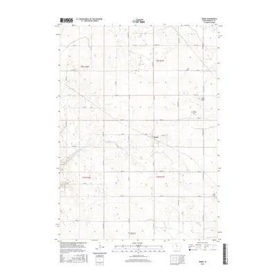
2015 Map of Hardy
USGS Topo · Published 2015About this map
Hardy sits at the center of this agricultural landscape in Humboldt County, defined by a rigid grid of rural roads and extensive water management. The area's reliance on managed waterways is evidenced by Drainage Ditch Number 4, which cuts across the terrain to support the productive farmland of the region. Local genealogy is well-documented through several scattered burial grounds, including the Swiss Cem in the north and the Hardy Trinity Lutheran Cem to the south. The presence of the Vernon Township Cem and the Lake Church Cem further reflects the community centers that once organized this prairie township. Small-scale aviation is represented by the Flying S Ranch Airport, while a network of county highways like CO Hwy C26 and CO Hwy P63 provides the primary infrastructure connecting these remote farmsteads and rural landmarks.
Find a feature on this map
35 named features on this map. Tap any name to fly to it.
Don’t see what you’re looking for? This feature index may not catch every label — zoom into the map to look around manually.
Map Details
Editions of this 2015 Hardy Map
This is the sole edition of this map. No revisions or reprints were ever made.
Other maps of this area

1923 · Fort Dodge
USGS Topo · 1:62,500

1954 · Waterloo
USGS Topo · 1:250,000

1954 · Fort Dodge
USGS Topo · 1:250,000

1955 · Waterloo
USGS Topo · 1:250,000

1957 · Fort Dodge
USGS Topo · 1:250,000

1958 · Fort Dodge
USGS Topo · 1:250,000

1972 · Corwith
USGS Topo · 1:24,000

1972 · St. Joseph
USGS Topo · 1:24,000

1972 · Renwick
USGS Topo · 1:24,000
1972 · Lu Verne
USGS Topo · 1:24,000