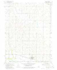
1974 Map of Hardy
USGS Topo · Published 1977About this map
The town of Hardy sits at the southern edge of Nuckolls County, precisely where the Nebraska state line meets Republic and Jewell Counties in Kansas. This 1970s survey captures a rural landscape defined by sophisticated water management and intersecting rail lines, most notably where the Burlington Northern and Missouri Pacific tracks converge near the settlement. The Superior Canal and multiple Siphons trace a path across the southern sections, illustrating the irrigation infrastructure vital to this prairie borderland.
Find a feature on this map
15 named features on this map. Tap any name to fly to it.
Don’t see what you’re looking for? This feature index may not catch every label — zoom into the map to look around manually.
Map Details
Editions of this 1974 Hardy Map
This is the sole edition of this map. No revisions or reprints were ever made.
Other maps of this area

1892 · Concordia
USGS Topo · 1:125,000

1894 · Mankato
USGS Topo · 1:125,000

1898 · Superior
USGS Topo · 1:125,000

1898 · Hebron
USGS Topo · 1:125,000

1955 · Manhattan
USGS Topo · 1:250,000

1955 · Lincoln
USGS Topo · 1:250,000

1955 · Grand Island
USGS Topo · 1:250,000

1955 · Beloit
USGS Topo · 1:250,000

1956 · Manhattan
USGS Topo · 1:250,000

1957 · Manhattan
USGS Topo · 1:250,000