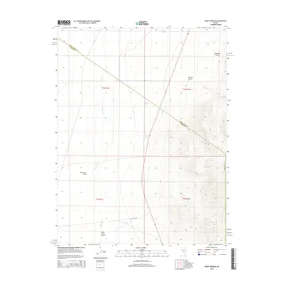
2014 Map of Hardy Springs
USGS Topo · Published 2014About this map
White River Valley defines this section of the Great Basin, where the ephemeral White River threads through high desert ranching country. The map documents a landscape shaped by scarce water sources, marking several critical watering points including Hardy Springs, Dee Gee Spring, and Blind Spring. This 2014 survey captures the remote boundary where White Pine and Nye Counties meet, showing a network of secondary routes like Wells Station Rd and CR-14 that cross the alluvial flats. To the east, the terrain rises sharply into the mountains, carved by Sheep Pass Canyon and Ninemile Canyon. The inclusion of the White Horse Pasture and Ruppes Boghole suggests the long-standing use of this valley for livestock, reflecting the traditional land use patterns of central Nevada.
Find a feature on this map
18 named features on this map. Tap any name to fly to it.
Don’t see what you’re looking for? This feature index may not catch every label — zoom into the map to look around manually.
Map Details
Editions of this 2014 Hardy Springs Map
This is the sole edition of this map. No revisions or reprints were ever made.
Other maps of this area

1956 · Lund
USGS Topo · 1:250,000

1960 · Lund
USGS Topo · 1:250,000

1969 · Shingle Pass
USGS Topo · 1:24,000

1969 · Moorman Spring SE
USGS Topo · 1:24,000

1969 · Moorman Spring NW
USGS Topo · 1:24,000

1969 · Moorman Spring
USGS Topo · 1:24,000

1969 · Moorman Spring NE
USGS Topo · 1:24,000

1969 · Haggerty Spring
USGS Topo · 1:24,000
1977 · Brown Knoll
USGS Topo · 1:24,000
1978 · Lund
USGS Topo · 1:24,000