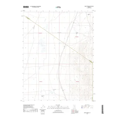
2018 Map of Hardy Springs
USGS Topo · Published 2018About this map
Hardy Springs and the expansive White Horse Pasture anchor this 2018 study of the high desert terrain along the border of Nye and White Pine counties. The landscape is defined by the ephemeral flow of the White River, which winds through the valley floor, supporting a network of water sources crucial to the area's grazing history. These natural features, including Blind Spring and the curiously named Ruppes Boghole, illustrate the precarious balance of water in this arid environment. To the east, the topography rises sharply into the high ridges surrounding Sheep Pass Canyon and Ninemile Canyon. This region remains largely open and transitional, served by historical transit routes like Wells Station Rd and various county roads that follow the natural contours of the basin and range.
Find a feature on this map
17 named features on this map. Tap any name to fly to it.
Don’t see what you’re looking for? This feature index may not catch every label — zoom into the map to look around manually.
Map Details
Editions of this 2018 Hardy Springs Map
This is the sole edition of this map. No revisions or reprints were ever made.
Other maps of this area

1956 · Lund
USGS Topo · 1:250,000

1960 · Lund
USGS Topo · 1:250,000

1969 · Shingle Pass
USGS Topo · 1:24,000

1969 · Moorman Spring SE
USGS Topo · 1:24,000

1969 · Moorman Spring NW
USGS Topo · 1:24,000

1969 · Moorman Spring
USGS Topo · 1:24,000

1969 · Moorman Spring NE
USGS Topo · 1:24,000

1969 · Haggerty Spring
USGS Topo · 1:24,000
1977 · Brown Knoll
USGS Topo · 1:24,000
1978 · Lund
USGS Topo · 1:24,000