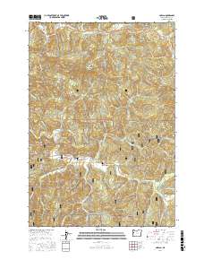
2017 Map of Harlan
USGS Topo · Published 2017About this map
Harlan serves as the central settlement in this portion of the Coast Range, located within the protected boundaries of the Siuslaw National Forest. The geography is defined by a dense network of timber-access routes and ridges, including Strom Boulder Ridge and Grant Ridge, which flank the winding course of Big Elk Cr. Local history is anchored at the Harlan Cem and the surrounding Big Elk Valley, where the confluence of numerous tributaries like Feagles Cr and Grant Cr shaped early settlement patterns. The map details a landscape managed for both preservation and resource extraction, evidenced by the transition from named peaks like Baldy and Cline Hill to the intricate web of forest development roads such as Burnt Woods Forest Rd and Nat For Dev Rd 30.
Find a feature on this map
72 named features on this map. Tap any name to fly to it.
Don’t see what you’re looking for? This feature index may not catch every label — zoom into the map to look around manually.
Map Details
Editions of this 2017 Harlan Map
This is the sole edition of this map. No revisions or reprints were ever made.
Other maps of this area

1939 · Marys Peak
USGS Topo · 1:62,500

1942 · Marys Peak
USGS Topo · 1:62,500

1942 · Alsea
USGS Topo · 1:62,500

1942 · Tidewater
USGS Topo · 1:62,500

1942 · Toledo
USGS Topo · 1:62,500

1953 · Salem
USGS Topo · 1:250,000

1954 · Salem
USGS Topo · 1:250,000

1956 · Alsea
USGS Topo · 1:62,500

1956 · Tidewater
USGS Topo · 1:62,500

1957 · Marys Peak
USGS Topo · 1:62,500