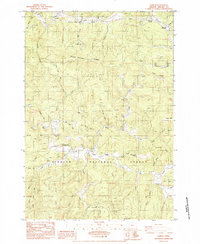
1984 Map of Harlan
USGS Topo · Published 1984About this map
Harlan serves as the central settlement in this portion of the Siuslaw National Forest, situated at the confluence of several mountain streams. The community's social and spiritual life is anchored by the Chapel of the Valley and an adjacent Cem., while the nearby Big Elk Forest Service Sta and Big Elk Campground reflect the area's administration and recreational utility during the mid-1970s and early 1980s. The landscape is defined by its complex drainage network, where Big Elk Creek and the Tumtum River carve through prominent terrain features like Strom Boulder Ridge and Chinquapin Ridge. A Quarry located near the forest service station suggests local resource extraction, likely supporting the network of forest roads and the Newport Highway that skirts the northern boundary. The presence of a major Transmission Line with Steel Towers cutting across the northern ridges indicates the region's role in the broader energy infrastructure of the Oregon Coast Range.
Find a feature on this map
47 named features on this map. Tap any name to fly to it.
Don’t see what you’re looking for? This feature index may not catch every label — zoom into the map to look around manually.
Map Details
Editions of this 1984 Harlan Map
This is the sole edition of this map. No revisions or reprints were ever made.
Other maps of this area

1939 · Marys Peak
USGS Topo · 1:62,500

1942 · Marys Peak
USGS Topo · 1:62,500

1942 · Alsea
USGS Topo · 1:62,500

1942 · Tidewater
USGS Topo · 1:62,500

1942 · Toledo
USGS Topo · 1:62,500

1953 · Salem
USGS Topo · 1:250,000

1954 · Salem
USGS Topo · 1:250,000

1956 · Alsea
USGS Topo · 1:62,500

1956 · Tidewater
USGS Topo · 1:62,500

1957 · Marys Peak
USGS Topo · 1:62,500