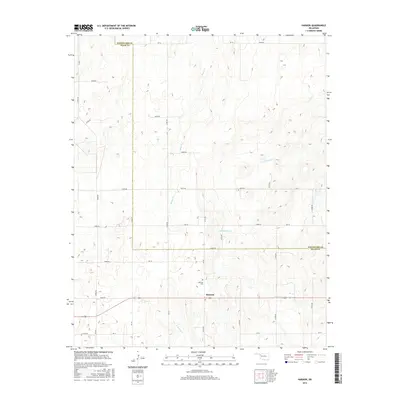
2016 Map of Harmon
USGS Topo · Published 2016About this map
Harmon sits at the southern edge of this West Oklahoma survey, serving as a focal point for the surrounding cattle country and wheat fields. This sparsely populated agricultural landscape is defined by the drainage basins of several prominent local waterways, including Turkey Creek, Boggy Creek, and North Persimmon Creek. The community identity is anchored by the Harmon Cemetery, situated just north of the town center. The map reveals the intricate sectional road grid typical of the Great Plains, where routes like Ew 58 and N190 Road follow surveyor lines across the gently undulating terrain. Straddling the boundary between Woodward and Ellis counties, the area remains an enduring example of the rural high plains, where water sources like South Turkey Creek dictated early settlement patterns and subsequent land use.
Find a feature on this map
36 named features on this map. Tap any name to fly to it.
Don’t see what you’re looking for? This feature index may not catch every label — zoom into the map to look around manually.
Map Details
Editions of this 2016 Harmon Map
This is the sole edition of this map. No revisions or reprints were ever made.
Other maps of this area

1955 · Woodward
USGS Topo · 1:250,000

1958 · Woodward
USGS Topo · 1:250,000

1969 · Fargo SW
USGS Topo · 1:24,000

1969 · Vici NW
USGS Topo · 1:24,000

1969 · Woodward SW
USGS Topo · 1:24,000

1969 · Fargo SE
USGS Topo · 1:24,000

1970 · Harmon
USGS Topo · 1:24,000

1970 · Harmon SW
USGS Topo · 1:24,000
1970 · Harmon SE
USGS Topo · 1:24,000
1970 · Harmon NW
USGS Topo · 1:24,000