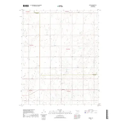
2018 Map of Harmon
USGS Topo · Published 2018About this map
Harmon serves as the primary focal point of this western Oklahoma landscape, situated near the boundary where Woodward Co and Ellis Co meet. The settlement is defined by its grid of rural routes, including E0600 Rd and Ew 61, which connect the scattered homesteads across the rolling plains. This 2018 survey reveals a drainage network dominated by several winding waterways, most notably Turkey Cr and S Turkey Cr to the south, while Boggy Cr and N Persimmon Cr cut through the northern sections. For those researching local lineages, the Harmon Cem is a significant landmark located just north of the town center. The map illustrates a contemporary rural economy still dictated by section lines and water access in a region where the vast open terrain is segmented by a precise network of numbered county roads.
Find a feature on this map
22 named features on this map. Tap any name to fly to it.
Don’t see what you’re looking for? This feature index may not catch every label — zoom into the map to look around manually.
Map Details
Editions of this 2018 Harmon Map
This is the sole edition of this map. No revisions or reprints were ever made.
Other maps of this area

1955 · Woodward
USGS Topo · 1:250,000

1958 · Woodward
USGS Topo · 1:250,000

1969 · Fargo SW
USGS Topo · 1:24,000

1969 · Vici NW
USGS Topo · 1:24,000

1969 · Woodward SW
USGS Topo · 1:24,000

1969 · Fargo SE
USGS Topo · 1:24,000

1970 · Harmon
USGS Topo · 1:24,000

1970 · Harmon SW
USGS Topo · 1:24,000
1970 · Harmon SE
USGS Topo · 1:24,000
1970 · Harmon NW
USGS Topo · 1:24,000