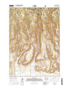
2017 Map of Harney
USGS Topo · Published 2017About this map
The high desert landscape of Harney and its surrounding ranchlands are documented in this 2017 survey. The settlement's historical footprint is anchored by the Harney Cem, while the northern portion of the map is dominated by the steep terrain of the Malheur National Forest. This area serves as a key drainage for several watercourses, including Coffeepot Cr and Rattlesnake Cr, which flow toward the lower basins.
Find a feature on this map
29 named features on this map. Tap any name to fly to it.
Don’t see what you’re looking for? This feature index may not catch every label — zoom into the map to look around manually.
Map Details
Editions of this 2017 Harney Map
This is the sole edition of this map. No revisions or reprints were ever made.
Other maps of this area

1955 · Burns
USGS Topo · 1:250,000

1958 · Burns
USGS Topo · 1:250,000

1959 · Burns
USGS Topo · 1:250,000

1959 · Harney
USGS Topo · 1:62,500

1961 · Calamity Butte
USGS Topo · 1:62,500

1968 · Van
USGS Topo · 1:62,500

1973 · Buchanan
USGS Topo · 1:24,000

1973 · Carson Point
USGS Topo · 1:24,000

1978 · Stinkingwater Mountains
USGS Topo · 1:100,000
1990 · Ninemile Slough
USGS Topo · 1:24,000