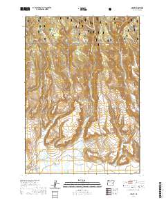
2020 Map of Harney
USGS Topo · Published 2020About this map
Harney serves as the focal point of this high-desert landscape in Harney County, situated where the open flats of the south meet the rising timber of the Malheur National Forest to the north. The area's settlement history is anchored by the Harney Cem, while the rugged drainage patterns of Coffeepot Cr and the various forks of Rattlesnake Cr define the local topography. This map highlights the transition from the pastoral Cow Creek Valley to the more confined spaces of Tudor Canyon and Mortimer Canyon. The presence of Mortimer Canyon Reservoir and scattered water sources like Shellrock Spring underscores the critical importance of water management in this arid Oregon environment. Local roads such as Harney Rd and Point Shyla Rd trace the paths through the high plains and canyons, providing a window into modern rural land use.
Find a feature on this map
28 named features on this map. Tap any name to fly to it.
Don’t see what you’re looking for? This feature index may not catch every label — zoom into the map to look around manually.
Map Details
Editions of this 2020 Harney Map
This is the sole edition of this map. No revisions or reprints were ever made.
Other maps of this area

1955 · Burns
USGS Topo · 1:250,000

1958 · Burns
USGS Topo · 1:250,000

1959 · Burns
USGS Topo · 1:250,000

1959 · Harney
USGS Topo · 1:62,500

1961 · Calamity Butte
USGS Topo · 1:62,500

1968 · Van
USGS Topo · 1:62,500

1973 · Buchanan
USGS Topo · 1:24,000

1973 · Carson Point
USGS Topo · 1:24,000

1978 · Stinkingwater Mountains
USGS Topo · 1:100,000
1990 · Ninemile Slough
USGS Topo · 1:24,000