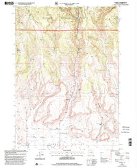
1999 Map of Harney
USGS Topo · Published 2002About this map
Fort Harney (Site) marks the historical center of this landscape where the high desert of the Harney Valley meets the timbered foothills of the Malheur National Forest. This late 1990s revision shows the small settlement of Harney and its nearby Cem, reflecting a quiet pastoral pocket in Harney County. The topography is defined by significant drainage systems, including Coffeepot Creek, Rattlesnake Creek, and Mill Creek, which flow southward out of steep canyons like Tudor Canyon.
Find a feature on this map
25 named features on this map. Tap any name to fly to it.
Don’t see what you’re looking for? This feature index may not catch every label — zoom into the map to look around manually.
Map Details
Editions of this 1999 Harney Map
This is the sole edition of this map. No revisions or reprints were ever made.
Other maps of this area

1955 · Burns
USGS Topo · 1:250,000

1958 · Burns
USGS Topo · 1:250,000

1959 · Burns
USGS Topo · 1:250,000

1959 · Harney
USGS Topo · 1:62,500

1961 · Calamity Butte
USGS Topo · 1:62,500

1968 · Van
USGS Topo · 1:62,500

1973 · Buchanan
USGS Topo · 1:24,000

1973 · Carson Point
USGS Topo · 1:24,000

1978 · Stinkingwater Mountains
USGS Topo · 1:100,000
1990 · Ninemile Slough
USGS Topo · 1:24,000