
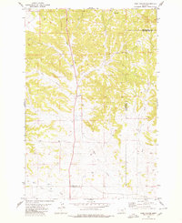
1979 Map of Harper Coulee
USGS Topo · Published 1980About this map
Harper Coulee carves through the central terrain of Musselshell County, defining a landscape marked by essential water sources and specialized land use in the late 1970s. The presence of Thompsons Water Hole and Hay Spr underscores the critical importance of reliable water access in this semi-arid region, likely supporting local livestock and ranching operations. To the north, Halfbreed Creek and Goulding Creek drain the higher elevations, while a Drill Hole and several wells suggest subsurface exploration and resource management. The map reveals a network of primitive roads and fence lines that segment the land, reflecting a period when range management and scattered hydrological points were the primary drivers of human activity across these coulees.
Find a feature on this map
11 named features on this map. Tap any name to fly to it.
Don’t see what you’re looking for? This feature index may not catch every label — zoom into the map to look around manually.
Map Details
Editions of this 1979 Harper Coulee Map
This is the sole edition of this map. No revisions or reprints were ever made.
Other maps of this area

1954 · Roundup
USGS Topo · 1:250,000

1958 · Roundup
USGS Topo · 1:250,000

1979 · Roundup
USGS Topo · 1:100,000

1979 · Elso
USGS Topo · 1:24,000

1979 · Hay Basin NE
USGS Topo · 1:24,000

1979 · Horsethief Creek
USGS Topo · 1:24,000

1979 · Gage
USGS Topo · 1:24,000

1979 · Roundup
USGS Topo · 1:24,000

1980 · Signal Mountain
USGS Topo · 1:24,000
1980 · Park Coulee
USGS Topo · 1:24,000