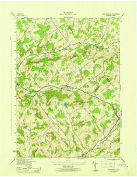
1946 Map of Harpersfield
USGS Topo · Published 1946About this map
Harpersfield and the surrounding townships of Kortright, Jefferson, and Stamford are depicted here just after the second World War, showing a landscape defined by dairy agriculture and high-elevation valleys. The Catskill Turnpike serves as a primary east-west artery through the map, connecting hamlets like West Harpersfield and North Kortright. The topography is a dense network of high points, including Titus Hill, Gunhouse Hill, and Peters Hill, which hem in narrow agricultural corridors. Local rural infrastructure is well-preserved in this record, featuring distributed landmarks like School No 5 and School No 6. To the southeast, the West Branch Delaware River flows near Stamford and Hobart, where the elevation begins to drop towards the river's wider valley. This survey provides a clear view of the Schoharie and Delaware County boundary during an era of stable, established rural life before modern development altered these traditional transport routes.
Find a feature on this map
38 named features on this map. Tap any name to fly to it.
Don’t see what you’re looking for? This feature index may not catch every label — zoom into the map to look around manually.
Map Details
Editions of this 1946 Harpersfield Map
This is the sole edition of this map. No revisions or reprints were ever made.
Other maps of this area

1904 · Richmondville
USGS Topo · 1:62,500

1904 · Hobart
USGS Topo · 1:62,500

1907 · Cooperstown
USGS Topo · 1:62,500

1909 · Cooperstown
USGS Topo · 1:62,500

1909 · Delhi
USGS Topo · 1:62,500

1911 · Delhi
USGS Topo · 1:62,500

1943 · Bloomville
USGS Topo · 1:24,000

1943 · Charlotteville
USGS Topo · 1:24,000
1943 · Schenevus
USGS Topo · 1:24,000

1943 · Summit
USGS Topo · 1:24,000