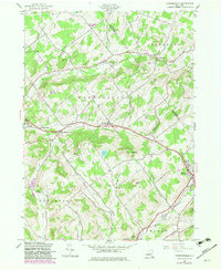
1982 Map of Harpersfield
USGS Topo · Published 1983About this map
Harpersfield and the surrounding Catskill foothills are defined by a network of small upland settlements and the winding headwaters of the West Branch Delaware River. This 1982 photorevision, based on mid-century surveys by the Army Map Service, documents the rural infrastructure of Delaware Co and Schoharie Co. Local history is preserved through labels for the Stevens Cem and Grant Cem, alongside early educational sites like School No 5 and School No 6. The landscape is a high-relief arrangement of peaks such as Mount Bob and Pan Hill, with the rail corridor through Stamford and Hobart marked as a Railroad Grade. These features illustrate the transition of the region's transport economy, as the old tracks that once served these dairy-producing communities were converted while the hamlets of North Harpersfield and West Harpersfield remained focal points of the valley.
Find a feature on this map
40 named features on this map. Tap any name to fly to it.
Don’t see what you’re looking for? This feature index may not catch every label — zoom into the map to look around manually.
Map Details
Editions of this 1982 Harpersfield Map
This is the sole edition of this map. No revisions or reprints were ever made.
Other maps of this area

1904 · Richmondville
USGS Topo · 1:62,500

1904 · Hobart
USGS Topo · 1:62,500

1907 · Cooperstown
USGS Topo · 1:62,500

1909 · Cooperstown
USGS Topo · 1:62,500

1909 · Delhi
USGS Topo · 1:62,500

1911 · Delhi
USGS Topo · 1:62,500

1943 · Bloomville
USGS Topo · 1:24,000

1943 · Charlotteville
USGS Topo · 1:24,000
1943 · Schenevus
USGS Topo · 1:24,000

1943 · Summit
USGS Topo · 1:24,000