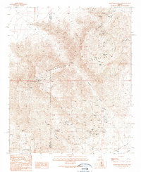
1990 Map of Harquahala Mountain
USGS Topo · Published 1990About this map
Harquahala Mountains rise as the dominant landform in this desert region, crossing the boundary between La Paz and Maricopa counties. The map reveals a landscape defined by 20th-century mineral exploration, with numerous prospects, adits, and mine shafts scattered across the slopes. Notable workings include the Monterey Mine Prospect and the Sunshine Mine, while an Open Pit Mine near Arrastre Gulch indicates more intensive extraction efforts. Higher elevations are marked by the presence of a Radio Tower atop Harquahala Mountain and the strategic gap of Sunset Pass. Despite the arid environment, several water sources like Cottonwood Spring and Seep Spring are documented, which likely served as vital points for early mining camps and prospectors navigating the canyons and washes.
Find a feature on this map
25 named features on this map. Tap any name to fly to it.
Don’t see what you’re looking for? This feature index may not catch every label — zoom into the map to look around manually.
Map Details
Editions of this 1990 Harquahala Mountain Map
This is the sole edition of this map. No revisions or reprints were ever made.
Other maps of this area

1942 · Vicksburg
USGS Topo · 1:250,000

1954 · Phoenix
USGS Topo · 1:250,000

1957 · Phoenix
USGS Topo · 1:250,000

1958 · Phoenix
USGS Topo · 1:250,000

1960 · Phoenix
USGS Topo · 1:250,000

1961 · Lone Mountain
USGS Topo · 1:62,500

1961 · Big Horn Mts
USGS Topo · 1:62,500

1961 · Gladden
USGS Topo · 1:62,500
1962 · Aguila
USGS Topo · 1:62,500

1969 · Phoenix
USGS Topo · 1:250,000