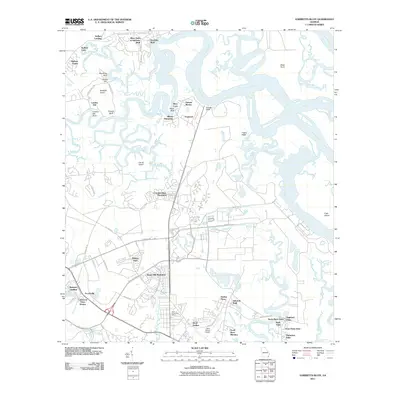
2011 Map of Harrietts Bluff
USGS Topo · Published 2011About this map
The tidal landscape of the Georgia coast is defined by the winding course of the Crooked River as it snakes toward Kings Bay and the Cumberland River. This 2011 survey shows a transition from historical agricultural footprints to contemporary residential developments, with legacy names like Elliotts Plantation and Sugar Mill Plantation now designating community clusters. The northern reaches are characterized by high bluffs and landings, including Harrietts Bluff and Sadlers Landing, which overlook a complex network of marshy islands and branches. Further south, the map reveals the infrastructure supporting the local population near the Florida border, including the Saint Marys Post Office and the Saint Marys Airport. The detailed road network, from Colerain Rd to Saint Marys Rd, illustrates the residential growth of settlements like Scotchville and Mission Trace within this intricate coastal environment.
Find a feature on this map
66 named features on this map. Tap any name to fly to it.
Don’t see what you’re looking for? This feature index may not catch every label — zoom into the map to look around manually.
Map Details
Editions of this 2011 Harrietts Bluff Map
This is the sole edition of this map. No revisions or reprints were ever made.
Other maps of this area

1918 · St Marys
USGS Topo · 1:62,500

1918 · Cumberland Island
USGS Topo · 1:62,500

1918 · Kingsland
USGS Topo · 1:62,500

1919 · Fernandina
USGS Topo · 1:62,500

1919 · St Marys
USGS Topo · 1:62,500

1930 · Cumberland Island
USGS Topo · 1:62,500

1944 · Fernandina
USGS Topo · 1:62,500

1945 · Cumberland Island
USGS Topo · 1:62,500

1948 · Jacksonville
USGS Topo · 1:250,000

1957 · Jacksonville
USGS Topo · 1:250,000