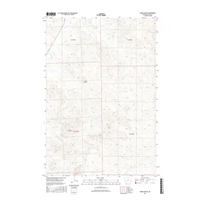
2017 Map of Harris Buttes
USGS Topo · Published 2017About this map
Harris Buttes and Wild Horse Mtn dominate this Custer County landscape, providing distinct topographical landmarks in a region defined by its complex drainage network. The area is dissected by numerous seasonal watercourses, including Pumpkin Cr and Anderson Cr, which carve through the high plains terrain. This 2017 survey illustrates the traditional township and range divisions of Eastern Montana, specifically spanning portions of T3N R49E and T2N R50E. The absence of concentrated settlements highlights the open, rural character of the territory, where the physical geography of Harris Cr and Road Cr dictates the local land use and boundary patterns. Researchers can trace the precise contours of the hills and the winding paths of Broughton Cr as they relate to historical grazing and land allotments in this part of the state.
Find a feature on this map
13 named features on this map. Tap any name to fly to it.
Don’t see what you’re looking for? This feature index may not catch every label — zoom into the map to look around manually.
Map Details
Editions of this 2017 Harris Buttes Map
This is the sole edition of this map. No revisions or reprints were ever made.
Other maps of this area

1953 · Miles City
USGS Topo · 1:250,000

1954 · Ekalaka
USGS Topo · 1:250,000

1956 · Ekalaka
USGS Topo · 1:250,000

1957 · Miles City
USGS Topo · 1:250,000

1958 · Miles City
USGS Topo · 1:250,000

1958 · Ekalaka
USGS Topo · 1:250,000

1965 · Ekalaka
USGS Topo · 1:250,000

1969 · Beebe SW
USGS Topo · 1:24,000

1969 · Miles City Creek
USGS Topo · 1:24,000
1969 · Beebe
USGS Topo · 1:24,000